Hat Tip: Laree
Cherokee Revealed - Translated Moravian records disclose a forgotten history
CHURCH MISSIONS: 19TH-CENTURY DOCUMENTS
Courtesy of Moravian Archives, Bethlehem, PA.
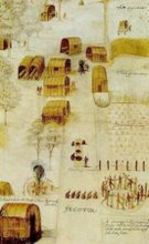
This map showing the settlements of the Cherokee Nation was drawn by Moravian missionary John Daniel Hammerer and is dated to 1766.
Published: September 8, 2009
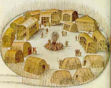
In front of the house stands a long, open shed covered with clapboards adequately provided with benches and other seats, as well as a raised plank for writing on. The Talk was held under this shed. At a short distance from this stands a tall pole. A designated Indian took his position at this pole with a drum, and beat the drum as a sign of the beginning of the meeting. He kept drumming until Indians were seen coming in lines. In the heat, the Indians used turkey wings in stead of fans to make a breeze for themselves. -- Report from Abraham Steiner, a Moravian missionary to the Cherokee at Springplace, Ga., May 22, 1801, translated from the German.
This glimpse into the shared history of Moravians and Cherokees was shrouded in archaic German script for over 200 years at the Moravian Archives in Winston-Salem.
The words were found among hundreds of diaries, letters and other papers that recorded about 100 years of history between the Moravian missionaries and their Cherokee brethren. The records constitute the only known account of daily life in the Cherokee nation.
In 1992, workers began to translate and transcribe the documents. But money grew tight and work slowed on the project because the staff had to consider prioritizing other projects and possibly cutting back hours or staff, said Daniel Crews, the archivist of the Moravian Church, Southern Province.
Then earlier this year, members of the Cherokee Nation made a $125,000 grant, to be paid over five years, to translate and transcribe the documents. The archives have committed two archivists to work on the collection two days a week for the next five years, Crews said, with the hope of publishing their findings in a series of books after the work is complete.
The Cherokee Nation is made up of those people descended from ancestors who survived the Trail of Tears, the removal of the Cherokee in 1838 from the Eastern United States to the Indian Territory, which is now Oklahoma.
The Eastern Band, the Cherokee whose ancestors went into the mountains rather than accept removal, have also agreed to help pay for the project, Crews said, but have not announced how much they will donate.
The records contain details about what the Cherokee ate, how they built their villages, and the way they danced and dressed.
Jack Baker, a member of the Cherokee Nation tribal council, said that such information is available nowhere else.
Cont. here:
http://www.journalnow.com/news/local/cherokee-revealed---translated-moravian-records-disclose-a-forgotten/article_7ab2e4dc-e315-5a72-ad4d-d9d99a15db1a.html
Click here to view all recent Searching for the Lost Colony DNA Blog posts
This blog is © History Chasers


